Population: 9,600
Other name: Shebeteria (?), Palua, Palios, Romanopolis, Palo
Market day: Wednesday
Favourite son: Selahattin Demirtaş (ex-leader of the HDP)
Out east of Elazığ on the Bingöl road and heading south from the nondescript small town of Kovancılar you will come to Palu, a small modern town on the banks of the Murat Nehri (Murat river) that lies in the lee of an abandoned historic settlement dating back at least to Urartian times and was the setting for desperate scenes in the early 20th century.
Backstory
Palu’s precise history remains obscure. The Urartians certainly settled the castle site that continued in use until the 17th century but the town’s flowering appears to have taken place from 1495 to 1850 when it was the seat of an obscure Kurdish emirate. It’s not even entirely clear when it was abandoned although since it seems to have been around the time of First World War it’s probably safe to assume that it was after much of its large Armenian population had been killed or expelled. The followers of Şeyh Said briefly captured Palu in 1925 so presumably much of the ruination dates from that time.
Around the ruins
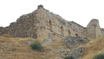
Signs direct you first towards Palu Kalesi, a dramatic craggy rock into which the Urartians hollowed their castle – only the fittest would be able to climb up to it now.
In the foothills of the rock though a dirt road leads to the late 16th-century Cemşit Bey Mescid in a pretty garden shaded by a mulberry tree. Chances are you’ll arrive to find it locked unless you visit at prayer time although you’ll be able to get into the colourful tomb of the founder, a military man who helped seize Palu for the Ottomans, and his family at the back. There are spectacular views of the castle and of the Murat river from beside the mosque. According to legend it was built on a site decided by firing an arrow from the castle.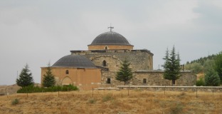
Up an easy path that starts close to the mosque lie the ruins of the large Merkez Cami built from yellow and black stone as recently as 1875 and still intact in 1973 according to the sign at the site even though it was last used inthe 1950s. It once formed the centrepiece of a shopping area of which no signs now remain.
 Right beside the ruined mosque stand the shards of the brick-domed Alacalı Mescid (Chequered Mescid), built from black and white stone in the late 16th century. Today it’s used as a cattle-shed.
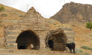
The dirt road continues to wind round until it comes to the ruins of the late 16th-century Küçük Cami (Small Mosque), with, across the road from it, the Ulu Cami (Great Mosque). According to the sign at the site this was registered in 1741 although it may be older than that. Inside the building many of the supporting arches still stand. The mihrab has also survived at least in part.
Beside the Ulu Cami are the ruins of a multi-domed hamam built in 1654, presumably as part of a complex with one of the two mosques. On the way back to the main dirt track look out on the left for two arches in the ground that apparently mark the site of a lost han. 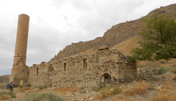 Ulu Cami
Beyond the Ulu Cami the dirt road continues round the base of Palu Kalesi until it comes to the ruins of the huge domed 19th-century Armenian Church of the Mother of God. Inside it’s just about possible to make out the bottom of frescoed figures on either side of the arch above the altar and slight traces of writing around the arch.
The road then winds downhill until you’ll see, on the left, another smaller but distinctive rock that can only be accessed through a farmyard. The sign says that the Urartians also used this for defensive purposes although I was unable to make out the steps cut into the rock or the niches it mentioned.
On the lefthand side of the rock at the bottom are the ruins of another simple church, perhaps Byzantine, that was converted into a mosque. It overlooks some dramatic rock formations above the river.
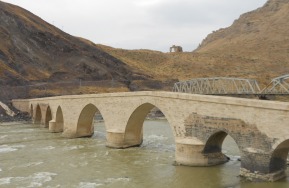 Below the rock you’ll see the suspension bridge that carries the railway over the river with, beside it, the restored eight-arched 4.Murat Köprüsü (Murat IV Bridge) which probably dates back to the 12th century. It acquired its name from the fact that the sultan rode across it on his way to campaign in Persia in 1638.
There are other ruins dotted about the site too. My taxi driver told me that there were once seven churches here and several hamams so there’s plenty more to look for.
Sleeping
Palu Kale Otel. On the hillside above the new town. Tel: 0555-195 2300.
Transport info
Half-hourly buses to Palu leave the Doğu Garajı (Eastern Garage) in Elazığ. Free servis buses run there from near the Orduevi taxi terminal in the centre of Elazığ.
Day trip destinations
Read more about Palu: http://turkeyfromtheinside.com/blogbloggingaboutturkey/entry/92-palu-a-forgotten-town-near-elazi%C4%9F.html
 Merkez Cami
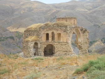 Armenian church